|
Travel
& Geography
Travel to the United States | The States & Territories | The Regions of the United States | Facts & Statistics |
|
|
The
States, Districts and Territories of the United States
> Virgin Islands
|
|
 Flag |
 |
|
Virgin Islands
|
|
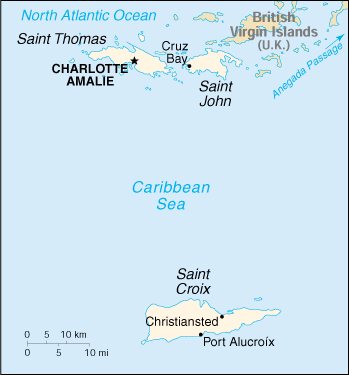
The Virgin Islands of the United States (pop.121,000 in 2000), 133 sq mi (344 sq km), are a U.S. territory. During the 17th century, the archipelago was divided into two territorial units, one English and the other Danish. The U.S. purchased the Danish territory in 1917 for $25 million because of the strategic position in the Angenda Passage, a key shipping lane to the Panama Canal. Unincorporated territory of the US with policy relations between the Virgin Islands and the US under the jurisdiction of the Office of Insular Affairs, US Department of the Interior. A governor and senate are locally elected. Since 1927, residents have enjoyed U.S. citizenship, and since 1973 they have been represented in the U.S. House of Representatives by a nonvoting delegate. GOVERNMENT Population (2002): 123,498; Population growth rate: 1.04% (2002 est.) Land Area: 133 sq mi (344 sq km) ECONOMY |
|
DISCLAIMER Any reference obtained from this server to a specific commercial product, process, or service does not constitute or imply an endorsement by the United States Government of the product, process, or service, or its producer or provider. The views and opinions expressed in any referenced document do not necessarily state or reflect those of the United States Government. |
|
U.S. Diplomatic Mission to Germany
/Public Affairs/ Information Resource Centers Updated: June 2003 |