|
The
States, Districts and Territories of the United States
> Palmyra Atoll
|
|
 Flag |
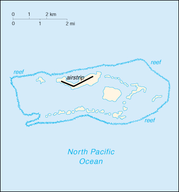 Palmyra Atoll. |
|
Palmyra Atoll
|
|
Oceania, atoll in the North Pacific Ocean, about one-half of the way from Hawaii to American Samoa. About 50 islets covered with dense vegetation, coconut trees, and balsa-like trees up to 30 meters tall. Incorporated territory of the US; privately owned, but administered from Washington, DC by the Office of Insular Affairs, US Department of the Interior. First visited by Americans in 1802, and later claimed by the Hawaiian kingdom (1862) and Great Britain (1889), it was annexed by the United States in 1898. Palmyra was under the jurisdiction of the city and county of Honolulu until Hawaii was granted statehood in 1959. The atoll is now under the control of the U.S. Dept. of the Interior. STATISTICSPopulation (2000): Not permanently inhabited Land Area: 2 sq mi/5.2 sq km |
|
DISCLAIMER Any reference obtained from this server to a specific commercial product, process, or service does not constitute or imply an endorsement by the United States Government of the product, process, or service, or its producer or provider. The views and opinions expressed in any referenced document do not necessarily state or reflect those of the United States Government. |
|
U.S. Diplomatic Mission to Germany
/Public Affairs/ Information Resource Centers Updated: June 2003 |