|
Travel
& Geography
Travel to the United States | The States & Territories | The Regions of the United States | Facts & Statistics |
|
|
The
States, Districts and Territories of the United States
> Northern Mariana Islands
|
|
 Flag |
 Northern Mariana Islands. |
|
Commonwealth of the Northern Mariana Islands
|
|
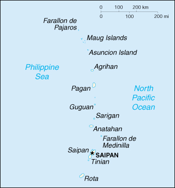
Located in Oceania, the Northern Mariana Islands include 14 islands in the North Pacific Ocean, about three-quarters of the way from Hawaii to the Philippines. The most important islands are Saipan, Rota, and Tinian. Before World War II, the Northern Mariana Islands were ruled successively by Spain, Germany, and Japan. Under US administration as part of the UN Trust Territory of the Pacific after World War II, the people of the Northern Mariana Islands decided in the 1970s not to seek independence but instead to forge closer links with the US. Negotiations for territorial status began in 1972. A covenant to establish a commonwealth in political union with the US was approved in 1975. A new government and constitution went into effect in 1978. The Commonwealth of the Northern Mariana Islands (CNMI) became part of the United States in Novenber 1986. GOVERNMENT Population 77,311 (July 2002 est.); average annual rate of natural increase: 3.49% Land Area: 184 sq. mi. (477 sq. km) ECONOMY |
|
DISCLAIMER Any reference obtained from this server to a specific commercial product, process, or service does not constitute or imply an endorsement by the United States Government of the product, process, or service, or its producer or provider. The views and opinions expressed in any referenced document do not necessarily state or reflect those of the United States Government. |
|
U.S. Diplomatic Mission to Germany
/Public Affairs/ Information Resource Centers Updated: June 2003 |